Category:Distribution maps of Gastropoda
Jump to navigation
Jump to search
| Upload media | |||||
| |||||
Subcategories
This category has the following 5 subcategories, out of 5 total.
Pages in category "Distribution maps of Gastropoda"
This category contains only the following page.
Media in category "Distribution maps of Gastropoda"
The following 64 files are in this category, out of 64 total.
-
 Albinaria hippolyti distribution in Crete.TIF 745 × 899; 655 KB
-

-
 Angulyagra microchaetophora map.png 901 × 837; 1.51 MB
-
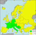
 Aplexa hypnorum Presence in European countries.png 1,262 × 1,213; 229 KB
-
 Assiminea brevicula map.png 901 × 837; 1.62 MB
-
 Assyriella thospitis menkhorsti - ZooKeys-171-017-g007.jpg 1,512 × 950; 667 KB
-
 Bellamya aeruginosa map.png 1,465 × 865; 2.87 MB
-
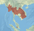 Bithynia siamensis map.png 901 × 837; 1.3 MB
-
 Blanfordia Early Miocene map.svg 190 × 267; 55 KB
-
 Blanfordia map.svg 309 × 306; 223 KB
-
 Blanfordia Pliocene map.svg 255 × 267; 57 KB
-
 Brotia distribution.jpg 858 × 861; 824 KB
-
 Brotia pagodula map.png 901 × 837; 794 KB
-
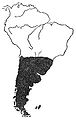
 Bulimulus Colonization of Galapagos.png 1,685 × 1,277; 8.21 MB
-
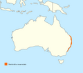
 C.ocel Range.png 1,196 × 795; 367 KB
-
 Chilinidae map.jpg 455 × 718; 70 KB
-
 Chrysomallon squamiferum map 2.png 1,400 × 832; 2.22 MB
-
 Chrysomallon squamiferum map.png 1,362 × 1,152; 2.69 MB
-
 Clea helena map.png 901 × 837; 1.34 MB
-
 Cochlostoma septemspirale Presence in European countries.png 1,262 × 1,213; 230 KB
-
 Cochlostoma septemspirale Presence in European countries.svg 2,132 × 2,048; 895 KB
-
 Conus abbas map.png 901 × 837; 1.44 MB
-
 Cremnoconchus carinatus map.png 901 × 837; 1 MB
-
 Cremnoconchus conicus map.png 901 × 837; 1 MB
-
 Cremnoconchus map.png 901 × 837; 1 MB
-
 Cremnoconchus syhadrensis map.png 901 × 837; 1 MB
-
 Deroceras invadens Distbn 2014.svg 851 × 426; 713 KB
-
 Destribution map of Cypraea fultoni.jpg 354 × 346; 93 KB
-
 Distribution of Angustopila dominikae.png 327 × 319; 55 KB
-
 Distribution-map-of-Hexaplex-trunculus.png 677 × 389; 19 KB
-
 Ferrissia tenuis map.png 901 × 837; 1,020 KB
-
 Fukuia Early Miocene map.svg 190 × 267; 55 KB
-
 Fukuia Pliocene map.svg 255 × 267; 57 KB
-
 Gulella streptostelopsis map.jpg 1,191 × 2,241; 649 KB
-
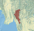
 Idiopoma javanica map.png 901 × 837; 1.34 MB
-
 Indoplanorbis exustus map.png 901 × 837; 1.55 MB
-
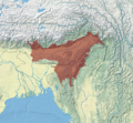
 Intha umbilicalis map.png 901 × 837; 1.57 MB
-
 Leavistrombus canairum distribution map.jpg 1,172 × 778; 341 KB
-
 Lobatus gigas map.png 708 × 561; 414 KB
-
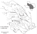
 Map of the Cahaba River and select tributaries - journal.pone.0042499.g001.png 1,838 × 2,908; 350 KB
-
 Mapa P antipodarum.svg 744 × 1,052; 69 KB
-
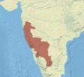
 Marstonia comalensis map.png 1,509 × 1,387; 477 KB
-
 Myosotella myosotis Presence in European countries.png 1,262 × 1,213; 232 KB
-
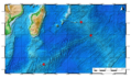
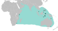
 Nembrotha aurea distribution map.png 3,711 × 1,929; 748 KB
-
 Nembrotha megalocera distribution map.png 563 × 506; 66 KB
-
 Nembrotha milleri distribution map.png 3,640 × 1,937; 570 KB
-
 Nembrotha mullineri distribution map.png 3,057 × 2,112; 409 KB
-
 Nembrotha rosannulata distribution map.png 298 × 260; 18 KB
-
 Nerita albicilla map.png 2,178 × 1,087; 387 KB
-
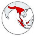
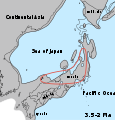
 Oncomelania minima map Japan.svg 309 × 306; 220 KB
-
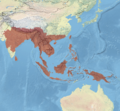
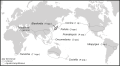
 Pachychilidae world.jpg 1,181 × 559; 609 KB
-
 Peringia ulvae Presence in European countries.png 1,262 × 1,213; 231 KB
-
 Pleurobranchus areolatus map.png 1,396 × 865; 3.22 MB
-
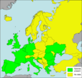
 Pomatias elegans Presence in European countries.png 1,262 × 1,213; 229 KB
-
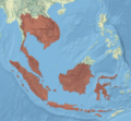
 Pomatiopsidae map.svg 586 × 322; 286 KB
-
 Potamopyrgus antipodarum map.png 600 × 402; 14 KB
-
 Potamopyrgus antipodarum Presence in European countries.png 1,262 × 1,213; 230 KB
-
 Semicassis granulata map.svg 1,500 × 775; 191 KB
-
 Semisulcospira libertina map.png 1,512 × 865; 2.5 MB
-
 Theodoxus fluviatilis - range map.png 1,280 × 580; 286 KB
-
 Tylomelania map.png 806 × 626; 110 KB
-
 Valvata piscinalis Presence in European countries.png 1,262 × 1,213; 227 KB
-
 Vilertia galeata distribution map.png 3,304 × 2,748; 1.26 MB
-
 Zasieg P antipodarum.svg 1,052 × 744; 94 KB


